Saturday, February 11, 2012

Intro to GPS


Well, to begin this blog I have to say how awkward I felt driving around my neighborhood, stopping at every fire hydrant, and tracking the coordinates. You know how someitmes you sit in your living room and you see a "creeper" driving up and down your streets and you think, "What the heck is this guy up to?" I was that creepy person today ;).

On that note, I actually had a lot of fun doing this. I used my Android phone, with the MyTracks application. I was able to share "with friends" right from the application to GE as a KML file. It was SUPER easy, and very interesting.

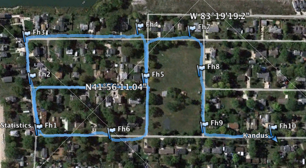
In my image, you can see that my coordinates are located in the 41N / 83W with varying minutes and seconds.  I labeled each hydrant as FH1-FH10. MyTracks also allows you to add notes to each marker, and that is where I chose to keep my thoughts on the condition of each hydrant.

To sum up, this lab on paper was very intimidating. Once I got out and mapped the coordinates I really surprised myself at how much fun I actually had. 


Wednesday, February 1, 2012

Conic Projections

I chose to do research on Conic Projections. After a few minutes of research I came across Polyconic Projections and I was very intrigued. As we learned in the lecture, conic projections show one or two parallels where the conic and spherical surfaces coincide. The best way to describe a polyclinic projection without using a photo can be found at www.progonos.com, "Cone constant varies from one at poles to infinity at the Equator, so the strips are not continuous, except along the central meridian. When infinitely many cones are used, each optimally tangent to a thin strip containing a single parallel, the gaps disappear; if the central meridian has constant correct scale, the result is the classic or common polyconic projection, also called American polyclinic." 


Below are images of the two:


Conic


Polyconic or American Polyconic

To sum up, the simplicity of the conic map is what first caught my attention. I had one of those "why didn't I think of that?" moments. Then I realized this form of map projection was perfected in the 1820's, and I'm a few hundred years behind. Regardless, conic map projections have proved to be very useful and are still used today.